 1
1Pangaea Drift
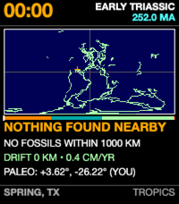
FacesA deep-time cartographic watchface for Pebble Time 2 (Emery). Midnight is 252 million years ago at the Triassic dawn; 23:59 marks the Cretaceous-Paleogene asteroid impact (66 Ma); and the final 60 seconds fast-forwards through 66 million years of continental drift to present-day Earth. The reticle carries your current ground back through deep time on its tectonic plate. FEATURES • Hero Digital Time: High-contrast 24px bold clock with stacked Geological Period and Age in Ma. • Deep-Time "Day Arc": 4px multi-colored ribbon tracking Earth's Mesozoic eras (Triassic Amber, Jurassic Cyan, Cretaceous Mint, Chicxulub extinction tick, and white cursor needle). • Continental Drift Map: Global coastlines reconstructed back through time using plate kinematics (Merdith et al., 2021). • Ancestral Reticle: Amber crosshair tracking your ancestral home coordinates as continents assemble and rift. • Hero Taxon & Telemetry: Nearby fossil occurrences from the Paleobiology Database, distance odometer, and paleo coordinates. • Bottom Bar: Home location anchor and paleo-climate band. • Customization: 12-hour / 24-hour time formatting and customizable color palette. Phone coordinates are resolved on-device via PebbleKit JS and cached to persistent storage for offline wear. Source: https://github.com/globe-and-atlas/pangaea-watch
 10
10Since Then
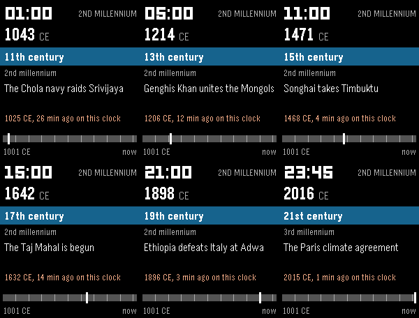
FacesSince Then squeezes a long stretch of time into one day. Midnight is the start of the span, the next midnight is now, and the face shows where this moment falls. Choose your timeline in settings: - Deep Time: Earth's 4.54 billion years - Holocene: since the ice age, 11,700 years - Common Era: since 1 CE - Second Millennium: since 1001 CE In Deep Time, oxygen fills the air mid-morning, animals appear after 21:00, the dinosaurs die at 23:39, and humans arrive seconds before midnight. The last minute ticks in seconds. Each screen shows the date on the timeline, the period or century, and the latest event with how long ago it happened on this clock. Geologic time follows the ICS International Chronostratigraphic Chart (v2024-12, CC BY 4.0), and every event is checked against its cited source. Fully offline. The clock is 24-hour on purpose, since midnight to midnight is the span. The colour of the time digits is configurable.
 4
4Constellation
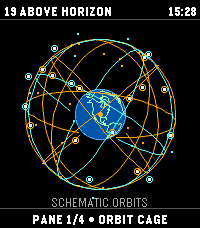
Tools & UtilitiesAn educational orbital-geometry watchapp for Pebble Time 2. Constellation propagates public CelesTrak GP/TLE element sets with SGP4 to plot modeled GPS, Galileo, GLONASS, and BeiDou positions. It is not a GNSS receiver: it does not receive satellite signals, produce a navigation fix, or estimate real-world positioning accuracy. TLE elements do not include an accuracy estimate. FOUR VIEWS • Orbit globe: modeled satellite positions; orbital-plane rings are schematic guides, not fitted to the TLEs. • Skyplot: modeled azimuth and elevation from the selected center. Bars show elevation only, not signal strength. • Geometry: DOP derived from modeled directions; singular or insufficient geometry displays N/A. DOP describes geometry, not position accuracy. • World map: simplified coastlines, selected center, and modeled sub-satellite points; no reception-radius circle. Phone coordinates are used on-device and are not sent to CelesTrak. Choose phone location or validated manual coordinates. A location failure is shown without a substitute location. TLE age is displayed; fresh elements require internet access. Cached elements can be viewed offline. Controls: hold UP/DOWN to change panes; click UP/DOWN on the globe to rotate; SELECT toggles catalog-number labels; hold SELECT refreshes. Data: CelesTrak GP/TLE. Source: https://github.com/globe-and-atlas/constellation-watch
 3
3Satellite Overpass
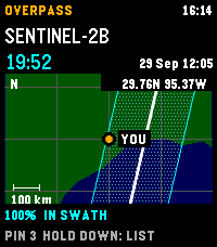
Tools & UtilitiesPlan Landsat 8/9 and Sentinel-2A/B/C passes over your location on Pebble Time 2. See a countdown, hourly cloud forecast, and modeled cross-track coverage. A 30-day history reports matching Earth Search scenes, whole-scene cloud cover, product-lag status, or a catalogue no-match. No-match does not prove that no acquisition occurred. The regional map shows your center, selected ground track, and nominal imaging swath; predictions and maps are cached for offline use. The map is an overview, unavailable above 80° latitude, and not live navigation. Sentinel-2A has a partial acquisition plan. Coverage and swath-edge status are geometric heuristics, not probabilities or guarantees. Cloud forecasts over five days have little skill. Refresh sends current coordinates to Open-Meteo for cloud forecasts and Element 84 Earth Search for scene history. Pin records stay in phone storage and are not included in those requests; open app settings to copy them as GeoJSON. Requires location permission for fresh local predictions and an internet connection for forecasts and scene history. Controls: UP/DOWN selects a pass; hold DOWN switches map/list; SELECT saves a timestamped pin; hold SELECT refreshes. Data: CelesTrak, Open-Meteo (CC BY 4.0), Element 84 Earth Search, Natural Earth (public domain). Source: https://github.com/globe-and-atlas/overpass-watch
 9
9From Here
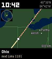
FacesYour location is the start. At 10:42 you are 10 degrees 42 minutes away along the direction you chose; the face shows where that is on a map, names the place, and tells you which town comes next. At midnight you are home again. Eight map directions (N, NE, E, SE, S, SW, W, NW; north-east adds one degree north and one degree east each hour) or Auto, which picks the direction with the most land and towns from home. Flick your wrist to cycle Now (~240 km), Hour (~600 km, default), Day (the whole route) and Globe; the default returns after a minute. Over open water the face widens to the Day view. Privacy: home is rounded to about 10 km and stays on the phone. By Globe & Atlas. Map data: Natural Earth (public domain) and GeoNames (CC BY 4.0).
 9
9Straight Ahead
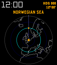
FacesThe world in azimuthal-equidistant projection, centred on you and turned to the way you face. A cyan ring sits one nautical mile out for every minute since midnight (one arcminute of great circle is one nautical mile), so at noon it is 12 degrees away and at 23:59 it touches the rim. The label names what lies where the ring crosses your heading: the nearest major city, or the sea, state or country there. Raise your wrist for 60 seconds of heading-up; flick during that minute for the whole-Earth view, where the vertical line is the great circle you face. By Globe & Atlas. Map data: Natural Earth.
 3
3Origin
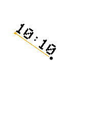
FacesThe time becomes the hand. A digital time string follows a twelve-hour dial, becoming a single upright numeral at exactly 3:00, 6:00, 9:00 and 12:00 for that minute. For Pebble Time 2, with 12 numeral fonts, hand color and width controls, and optional weekday, date, month and year at the top or bottom. Prototype by Globe & Atlas. Preview animation is an accelerated time-lapse; the watch updates once per minute.
 4
4Vector
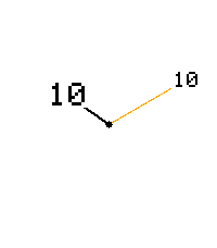
FacesTwo hands, two numbers. The hour sits near the shorter hand tip and the minutes near the longer hand tip; both numbers stay upright. For Pebble Time 2, with 12 numeral fonts, independent hand colors and widths, and optional weekday, date, month and year at the top or bottom. Prototype by Globe & Atlas. Preview animation is an accelerated time-lapse; the watch updates once per minute.
 8
8Meridian
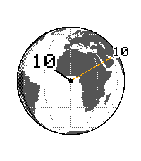
FacesA globe beneath two numbered hands for Pebble Time 2. Calculated day/night shading follows UTC and the season while the clock follows local watch time. Choose a world view, manual location, or optional coarse phone location. Includes upright numerals, 12 fonts, independent hand colors and widths, and optional date fields. The simplified globe shows calculated sunlight, not weather. Prototype by Globe & Atlas. Preview animation is an accelerated time-lapse; the watch updates once per minute.
 5
5Cardinal
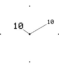
FacesFine black hands, upright hour and minute numbers, and four cardinal points. A minimal watchface for Pebble Time 2 with 12 numeral fonts, independent hand colors and widths, and optional weekday, date, month and year at the top or bottom. Prototype by Globe & Atlas. Preview animation is an accelerated time-lapse; the watch updates once per minute.